Tarih: Issue 76 - July 2017
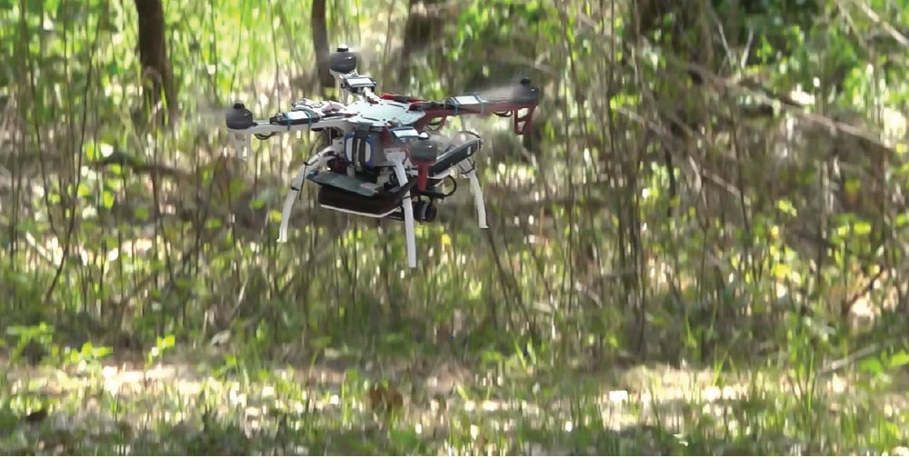
Phase 1 of DARPA’s Fast Lightweight Autonomy (FLA) program concluded recently following a series of obstacle-course flight tests in central Florida. Over four days, three teams of DARPA-supported researchers huddled under shade tents in the sweltering Florida sun, fine-tuning their sensor-laden quadcopter unmanned aerial vehicles (UAVs) during the intervals between increasingly difficult runs.
DARPA’s FLA program is advancing technology to enable small unmanned quadcopters to fly autonomously through cluttered buildings and obstacle-strewn environments at fast speeds (up to 20 meters per second, or 45 mph) using onboard cameras and sensors as “eyes” and smart algorithms to self-navigate. Potential applications for the technology include safely and quickly scanning for threats inside a building before military teams enter, searching for a downed pilot in a heavily forested area or jungle in hostile territory where overhead imagery can’t see through the tree canopy, or locating survivors following earthquakes or other disasters when entering a damaged structure could be unsafe.
“The goal of FLA is to develop advanced algorithms to allow unmanned air or ground vehicles to operate without the guidance of a human tele-operator, GPS, or any datalinks going to or coming from the vehicle,” said JC Ledé, the DARPA FLA program manager. “Most people don’t realize how dependent current UAVs are on either a remote pilot, GPS, or both. Small, low-cost unmanned aircraft rely heavily on tele-operators and GPS not only for knowing the vehicle’s position precisely, but also for correcting errors in the estimated altitude and velocity of the air vehicle, without which the vehicle wouldn’t know for very long if it’s flying straight and level or in a steep turn. In FLA, the aircraft has to figure all of that out on its own with sufficient accuracy to avoid obstacles and complete its mission.”
The FLA program is focused on developing a new class of algorithms that enables UAVs to operate in GPS-denied or GPS-unavailable environments—like indoors, underground, or intentionally jammed—without a human tele-operator. Under the FLA program, the only human input required is the target or objective for the UAV to search for—which could be in the form of a digital photograph uploaded to the onboard computer before flight—as well as the estimated direction and distance to the target. A basic map or satellite picture of the area, if available, could also be uploaded. After the operator gives the launch command, the vehicle must navigate its way to the objective with no other knowledge of the terrain or environment, autonomously maneuvering around uncharted obstacles in its way and finding alternative pathways as needed.
The recent four days of testing combined elements from three previous flight experiments that together tested the teams’ algorithms’ abilities and robustness to real-world conditions such as quickly adjusting from bright sunshine to the dark building interiors, sensing and avoiding trees with dangling masses of Spanish moss, navigating a simple maze, or traversing long distances over feature-deprived areas. On the final day, the aircraft had to fly through a thickly wooded area and across a bright aircraft parking apron, find the open door to a dark hangar, maneuver around walls and obstacles erected inside the hangar, locate a red chemical barrel as the target, and fly back to its starting point, completely on their own.
Each team showed strengths and weaknesses as they faced the varied courses, depending on the sensors they used and the ways their respective algorithms tackled navigation in unfamiliar environments. Some teams’ UAVs were stronger in maneuvering indoors around obstacles, while others excelled at flying outdoors through trees or across open spaces.
The test runs had the combined feel of part air show, part live-fire exercise, with a palpable competitive vibe between the teams. “The range is hot, the range is hot, you are cleared to launch,” crackled the voice of the test director over the walkie-talkies audible in the adjacent team tents, giving a green light to launch an attempt. Sitting under his own shaded canopy, the director followed the UAV’s flight on two video monitors in front of him, which showed views from multiple cameras placed along the course. Metal safety screens, which resembled giant easels, protected the camera operators on the course, as well as teams and course officials, from any rogue UAVs.


.jpg)